June 17, 2023: Premier Americana – Day Two
Sat, Jun 17, 2023 09:00AM EDT

| Price | Bid Increment |
|---|---|
| $0 | $10 |
| $200 | $25 |
| $500 | $50 |
| $1,000 | $100 |
| $3,000 | $250 |
| $5,000 | $500 |
| $10,000 | $1,000 |
| $30,000 | $2,500 |
| $50,000 | $5,000 |
| $100,000 | $10,000 |
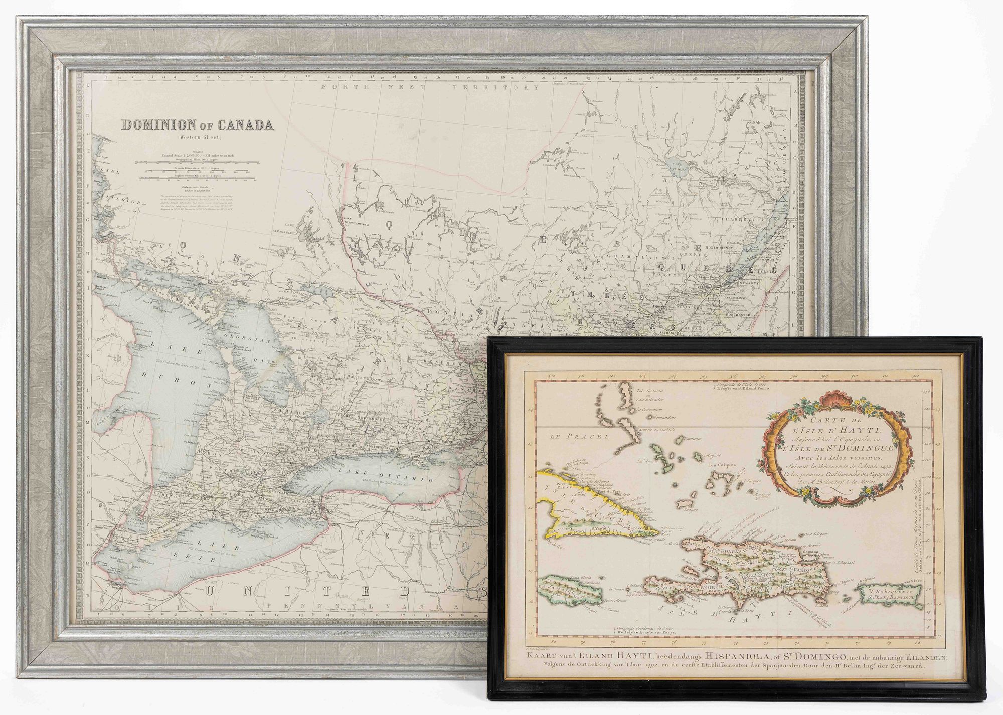
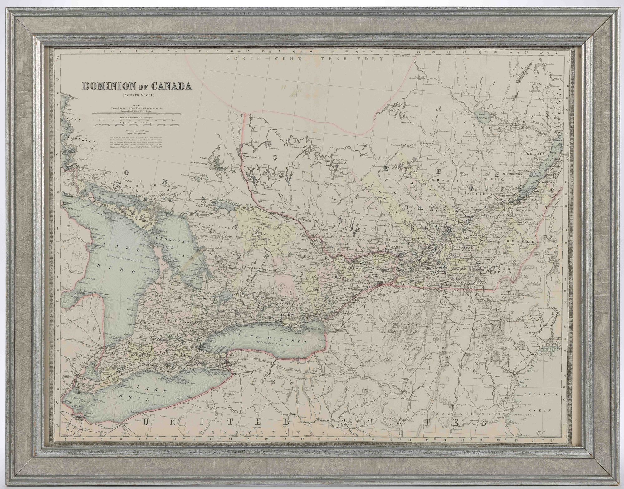
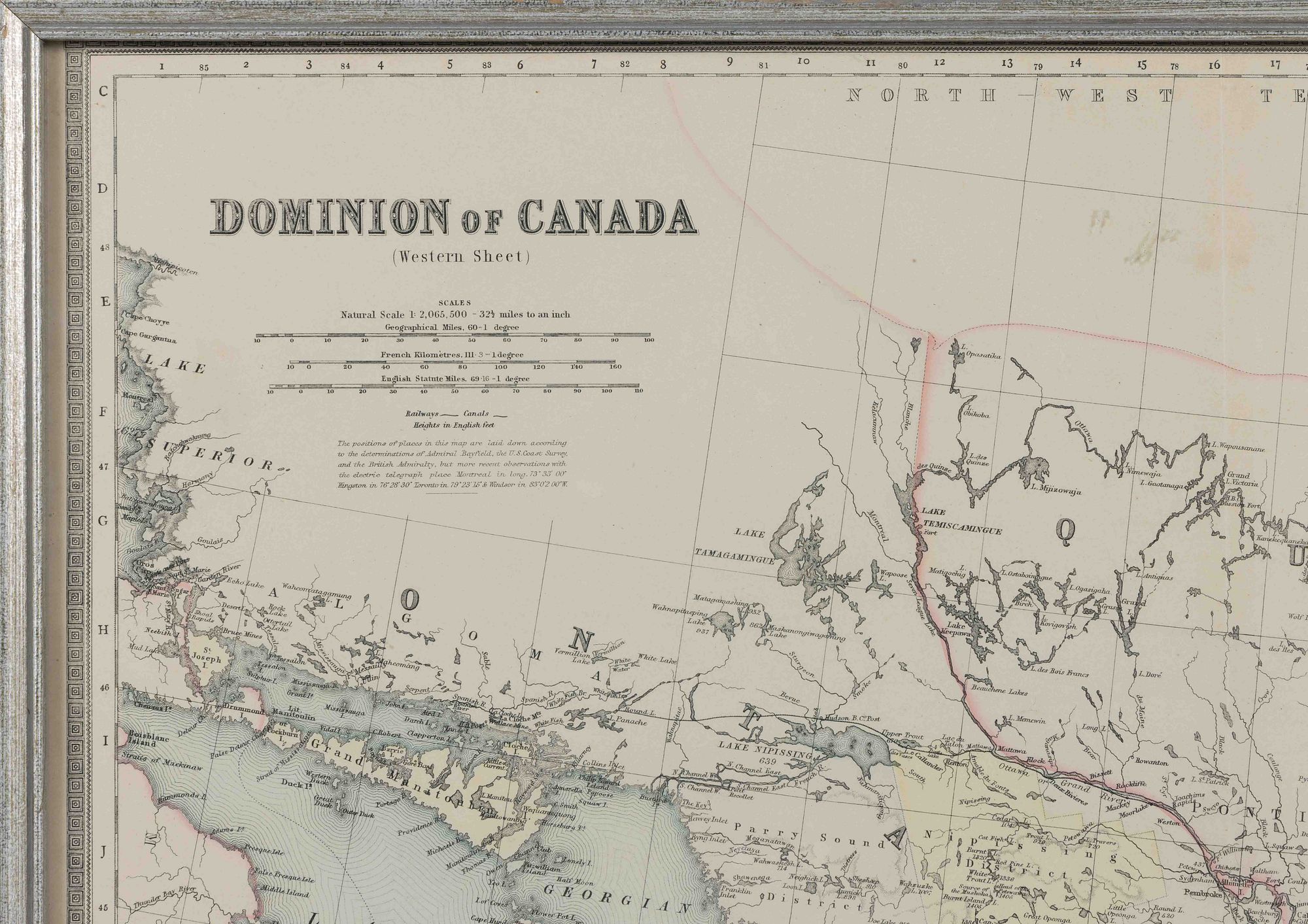
ASSORTED NORTH AMERICAN AND CARIBBEAN MAPS, LOT OF TWO, hand-colored engraving and lithograph on paper, comprising a map of Canada after William and Alexander Keith Johnston (Scottish), titled "DOMINION OF CANADA / (Western Sheet)" in the upper left corner, featuring Ontario and Quebec, bordered by three of the Great Lakes, Michigan, and northeastern region of the United States including New York; and a map of Caribbean islands after Jacques Nicolas Bellin (French, 1703-1772), titled "CARTE DE / L'ISLE D'HAYTI, / Anjour d'hui l'Espagnole, ou / L'ISLE DE ST. DOMINGUE, / Avec les Isles voisines; / Suivant la Decouverte de l'Annee 1492, / Et les premiers Etablissemens de Espagnols / Par M. Bellin, Ingr. de la Marine." in a Rococo-style cartouche in the upper right corner, "J. V. Schley, direx." in lower left corner for Jakob van der Schley (Dutch, 1715-1779), featuring Cuba, Haiti, Jamaica, and Puerto Rico, lower margin with caption in Dutch. Each housed under glass in a modern frame. Late 18th and late 19th century. "CANADA" 23 1/2" x 17 1/2" sight, 27" x 21" OA; "HAYTI" 14 1/8" x 10" sight, 15 3/8" x 11 1/4" OA.
Each in very good visual condition with some light toning; "CANADA" with center vertical fold line having a tear starting at bottom edge being approximately 3 1/2" to 4" in length, some fading to watercolor, frame with minor wear; "HAYTI" with typical fold lines, a loss to lower right corner not affecting the image or caption, frame with minor wear and a few flakes, chipping to lower proper left corner. Not examined out of frames.
Available payment options


When you are a successful bidder with us you may choose to utilize our in house pack and ship team, pick up your items yourself, or use a third party mover. Shipping within the USA is done through UPS unless otherwise requested and internationally through USPS. We ship to the address on your invoice. We are required by law to collect Virginia State Sales Tax and Nexus Tax where applicable. If you are exempt please read below. List of Third-Party Shippers VIEW LIST Sales Tax on Shipped Purchases Any item purchased by an off-site bidder (e.g. absentee bid, Internet bid, telephone bid,) that is shipped out of the state of VA is subject to sales tax of their state as determined by the Nexus Sales Tax Law. Any item purchased in person at our gallery and then shipped, either in-state or out-of-state, is subject to VA sales tax (because the item was purchased in the state of VA). EXCEPTION: Dealer purchase with all required tax exemption documentation on file. Additional Sales Tax Information may be found on the Virginia Department of Taxation website. Shipping/Packing The buyer is responsible for all associated shipping costs. Credit card on file required for all shipping. Credit card automatically charged once items are packed and ready to ship. Receipt sent to email on file. Standard shipping charges include our packing fee, any applicable materials fee and the cost of delivery with insurance based on the carriers’ current rates. Preferred carriers are UPS (United Parcel Service) within the USA and USPS (United States Postal Service) outside the USA. Our packing service is billed at a prorated fee of $18.00 per hour, with a $10.00 minimum. We use recycled materials whenever possible at no charge to the buyer. If we use purchased supplies such as boxes, etc., that cost is passed on to the buyer. Our UPS account provides for a daily pick up at our gallery, therefore, no handling fee applies to packages shipped via UPS. We offer a professional in-house packing and shipping service and regularly pack and ship glass, ceramics, and antiques and collectibles of all types; however, we do not crate or pack/ship large and/or heavy objects (e.g. furniture, statuary) or items that are unusually fragile (i.e. severely cracked vase). If you are unsure if we can ship a lot for you, please ask before you bid. It is our policy to double-box all glass, ceramics and fragile items with 2-3 inches of padding/cushioning between the inner and outer boxes. We ship for an average of 450 customers after each auction with great success (including international shipments) and we will not compromise on this packing method. You are welcome to make other shipping arrangements if desired. A list of alternate shippers can be provided upon request. We will combine multiple items/lots for shipping whenever possible. If you won by bidding with us directly and also through our online platforms, we can easily combine lots to save on shipping costs. We will gladly provide estimated shipping costs up to one hour prior to the start of the auction. Please call 540.434.3939, ext. 0 or email us with the lot number(s) in which you are interested as well as the delivery zip/postal code and country. It is our sincere intent to provide an accurate shipping estimate (within 20% of actual cost), but we are under no obligation to honor an estimated shipping cost. Post-auction requests for shipping estimates/quotes may delay the actual packing of your items by 1-2 business days. We pack/ship in order of request. We often receive 75-80 requests per day in the first few days following an auction and process approximately 60 shipments per week. Your patience is appreciated. Since items must be packed in order to determine shipping charges, you may elect to send payment by check and provide a credit card for the shipping charges. Shipping charges paid by credit card are not subject to an additional fee. If we have packed for shipping per your request, but the item is ultimately picked up at our gallery, the packing fee will still apply. The buyer is responsible for coordinating pick up or shipment of any merchandise that we do not ship. Such items must be paid in full before leaving our gallery. Buyers are not obligated to use our packing/shipping service and are welcome to make other arrangements. We recommend our local UPS Store, Plycon Transportation Group or you may wish to contact a shipper from this list or search the internet for other options. Merchandise that we do NOT ship must be picked up within two (2) weeks of the sale date unless other arrangements have been authorized by JSE&A. Items not picked up within this time are subject to the storage fees listed below. Any items with an outstanding shipping fee will be subject to the storage fees listed below. The grace period begins once the buyer is notified of shipping charges. Pick Up If picking up at our gallery (2177 Green Valley Lane, Mt. Crawford, VA 22841), please let us know in advance! Our standard hours are Mondays through Fridays from 9:00 am to 5:00 pm ET. If you cannot pick up during the week, you may come during one of our Saturday auctions to pick up; however, we MUST know in advance if you plan to pick up during an auction. On auction days, we open at 8:00 am ET and are here until the end of the auction which varies depending on the number of lots ** Storage Fee Information Items won must be picked up within (2) weeks after the date of the auction. Any items not picked up within (2) weeks of the sale are subject to an additional storage fee. After 35 days, there will be a storage fee implemented, of $10 per day, per large item e.g. furniture, and $5 per day, per small item. Any items that have not been picked up within (90) days of the sale will be considered abandoned and will be resold. UPS & USPS A physical address is required for delivery by UPS. Our default shipping method within the USA is UPS Ground. An adult signature will be required for the delivery of any UPS package with a value of $1,000 or more and any packages that contain antique firearms. Our UPS account provides for a daily pick up at our facility (Monday through Friday only); therefore, with the exception of Canadian and International shipments, UPS is generally less expensive than USPS. No handling fee applies to packages shipped via UPS. If UPS determines that the deliver to address is invalid and subsequently makes a correction in order to deliver your package, an address correction fee may apply. (Currently $18.) (Corrections may include the addition of an apartment or suite number, correction to the street name, correction to zip code, etc.) Be sure to include any additional address information when registering. Shipment of won lots to an address different from that on file may require verification, which can cause up to a 30-day delay in shipping. If we are NOT shipping to the address on your invoice, we must have the alternate delivery address BEFORE packing is completed. If we must make corrections to the delivery address AFTER packing is completed, an additional service charge may apply. Insurance is mandatory unless the buyer provides a written waiver of insurance coverage. The waiver may be sent via email to us provided the email used is the one associated with the winning bidder account. If you have specific packing/shipping instructions (e.g. no insurance, do not double-box), your instructions must be submitted in written form and you accept full responsibility. (Email is acceptable provided that the email used is the one associated with the bidder account.) Unless the buyer has his or her own insurance, shipping without insurance coverage is not recommended and is at the buyer’s risk. Most international shipments are sent via USPS PMI (Priority Mail International); however, restrictions/limitations on allowed package size and insurance coverage vary from country to country. The USPS GXG (Global Express Guaranteed) shipping method may allow additional insurance coverage, but this shipping option is typically much more expensive. We will NOT alter our invoices or customs forms to reflect lesser item value. Invaluable and LiveAuctioneers Winners The address shown on your invoice is as entered in your Invaluable or LiveAuctioneers account. To update how your information displays on your invoice, log in to your Invaluable or LiveAuctioneers account, go to your Profile Page and then Edit Account. Please inform us if you make updates to your Invaluable or LiveAuctioneers account details before your transaction has been completed as it will affect the buyer details shown on your invoice.